
Longitude and Latitude of India are known as geographical coordinates, forming a grid system that helps map the Earth’s surface features accurately. These coordinates enable easy identification of a location’s position, direction, and distance. They are expressed in degrees (°) as they denote angular measurements. Each degree is divided into 60 minutes (′), and each minute into 60 seconds (″). This systematic division allows precise navigation and location tracking, making latitude and longitude essential tools in geography, navigation, and mapping. Bookmark this article for more detailed information on the Longitude and Latitude of India.
What are Latitude and Longitude?
Latitude and longitude are two fundamental concepts in geography and cartography that help pinpoint any location on Earth’s surface. Longitude and latitude of India play an important role in navigation and mapping, which offer precise information about the location across the earth. Here is the detailed information about Latitude and Longitude.
Latitude:
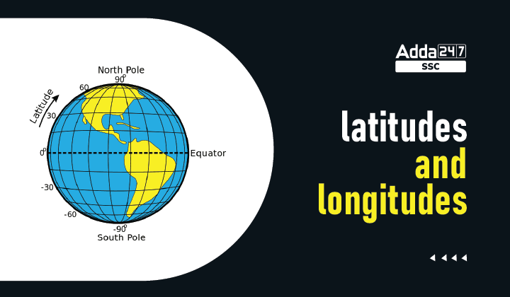
- Latitude is defined as the angular distance of any point north or south of the equator, i.e., it is a coordinate system that is used as a reference point to locate places on Earth.
- The Equator is an imaginary circular line drawn on the Earth, which divides it into two equal parts, wherein the upper half is called the Northern Hemisphere, and the lower half is known as the Southern Hemisphere. The circular lines, parallel to the equator, and up to the North and South poles are the parallels of latitude.
- Latitude ranges from 0 to 90 degrees, with the equator indicating 0 degrees and the poles indicating 90 degrees. The Equator is the longest line of latitude. Parallels in the northern hemisphere are referred to as north latitudes, while those in the southern hemisphere are referred to as south latitudes. The following are some major latitudes:
- Tropic of Cancer (23.5° N)
- Tropic of Capricorn (23.5° S)
- Arctic Circle (66.5° N)
- Antarctic Circle (66.5° S)
Longitude:
- Longitude is the angular distance of any point east or west of the Prime Meridian or west of the Standard Meridian. It determines how far a specific location is from the reference line. Meridians of longitude are reference lines that run from the north pole to the south pole. These are semicircles, and the distance between them decreases sharply as they approach the poles.
- All meridians are the same length, and the Greenwich Meridian is used to count meridians. The prime meridian has a value of 0° longitude and divides the Earth into two equal parts, the Eastern and Western Hemispheres.
Here’s a helpful YouTube video that explains the Longitude and Latitude of India concept in detail:
Difference between Latitude and Longitude
The difference between Latitude and Longitude according to the direction and climate has been explained below.
- Zero Point: The Prime Meridian serves as the zero point for longitude, with lines extending east and west. The Equator serves as the zero point for latitude, with lines extending north and south.
- Effect on Climate: Latitude plays a significant role in determining climate zones, such as tropical, temperate, and polar regions. Longitude affects time zones, with each 15° longitude difference roughly one hour.
- Direction: Longitude measures the distance east or west of the Prime Meridian, and latitude measures the distance north or south of the Equator.
The difference between Longitude and Latitude of India is given in the table below:
| Basis For Comparison | Latitude | Longitude |
|---|---|---|
| Meaning | Latitude implies the geographic coordinate that determines the distance of a point south of the equator. | Longitude alludes to the geographic coordinate, which identifies the distance of a point west of the Prime Meridian. |
| Direction | East to west | North to south |
| Stretches from | 0 to 90° | 0 to 180° |
| Lines of reference | Known as parallels | Known as meridians |
| Number of lines | 180 | 360 |
| Length of lines | Different | Same |
| Parallel | Yes, the lines are parallel. | No, the lines are not parallel. |
| Classifies | Heat Zones | Time Zones |
Longitude and Latitude of India
India is a vast country. Lying entirely in the Northern Hemisphere, the mainland extends between latitudes 8°4’N and 37°6’N and longitudes 68°7’E and 97°25’E. The Indian Government has accepted the meridian of 82.5° east for the standard time, which is 5 hours 30 mins ahead of Greenwich Mean Time. In India, longitude lines help determine the country’s position relative to the Prime Meridian. By understanding these geographic coordinates, one can precisely identify the position of cities, landmarks, and natural features, facilitating various activities such as travel, urban planning, and disaster management.


 Top 10 Longest Rivers in India, Largest ...
 Mughal Empire Notes For RRB NTPC Exam 20...
 Parliament of India Notes: Members, Func...